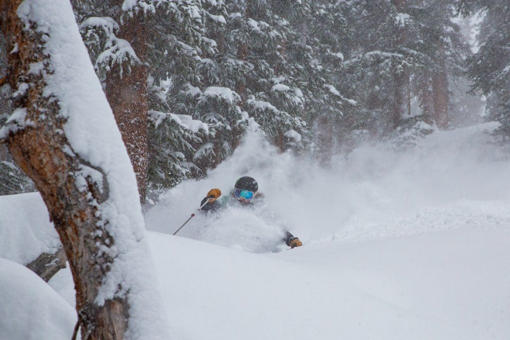
Summit County ski areas tally as much as 28 inches from 2-day storm with more on the way

Ian Zinner / Arapahoe Basin Ski Area
DILLON — For those who got to spend the past couple of days on the slopes rather than stuck in traffic on Interstate 70, this storm has lived up to the hype.
Heavy snow closed Summit County schools Friday, and when you live in the mountains, a snow day is a ski day.
On Thursday, OpenSnow meteorologist Sam Collentine was calling for heavy bands of snow that could drop flakes at a rate of 1-3 inches per hour. That intense snowfall materialized, meaning free refills of powder at Summit ski areas.
Breckenridge Ski Resort was the big winner out of the storm, totaling more than 2 feet of snow — 28 inches — on its Friday and Saturday reports combined. Loveland Ski Area’s two-day total was 21 inches, Arapahoe Basin Ski Area and Copper Mountain Resort tied at 17 inches, and Keystone reported 12 inches.
And the storm is not over yet.
Summit County remains under a winter storm warning until 11 p.m. Saturday, with snow expected to continue into Sunday.
National Weather Service meteorologist Greg Hanson said snowfall is expected to pick back up Saturday afternoon before tapering off at about midnight.
He expects the Summit County ski areas will pick up another 10-12 inches though Saturday night with 4-6 inches forecast to fall in the towns.
Keep up with the conditions:
• Forecast and recent weather stories: summitdaily.com/news/weather.
• Storm warnings and advisories: wrh.noaa.gov
• Summit County ski area forecasts: opensnow.com/region/summitcounty
• Road conditions, closures and traffic cameras: cotrip.org.
• Travel information by phone: 511 (in Colorado) or 303-639-1111.
• Sign up for CDOT alerts: codot.gov/topcontent/travel-alerts-system/for-general-public.
• Avalanche danger and conditions: avalanche.state.co.us.
• Flight information: flightview.com/traveltools.
On Sunday, Hanson said scattered snow showers are expected to drop 3-5 inches in the mountains with 1-3 inches in the towns before the storm rolls out of the area.
With the most intense part of the storm over, Hanson also said that the wind should not be as bad Saturday, with 30-40 mph gusts expected on high mountain passes.
Avalanche danger remains high in the Summit County and Vail areas. It’s also listed as high in the nearby Steamboat and Flat Tops, Front Range, Aspen, Gunnison and Sawatch regions, according to the Colorado Avalanche Information Center.
Summit and Vail remain under an avalanche warning through 8 a.m. Sunday.
“Large human triggered avalanches are likely near and above treeline,” according to the warning. “If you trigger an avalanche it will break near the ground and will be large enough to bury or kill you.”
Avalanche danger is rated high (very dangerous) above and near tree line, and considerable (dangerous) below tree line, according to the avalanche forecasting site.
The danger is expected to subside slightly Sunday to considerable (dangerous).


Support Local Journalism
Support Local Journalism
As a Summit Daily News reader, you make our work possible.
Summit Daily is embarking on a multiyear project to digitize its archives going back to 1989 and make them available to the public in partnership with the Colorado Historic Newspapers Collection. The full project is expected to cost about $165,000. All donations made in 2023 will go directly toward this project.
Every contribution, no matter the size, will make a difference.