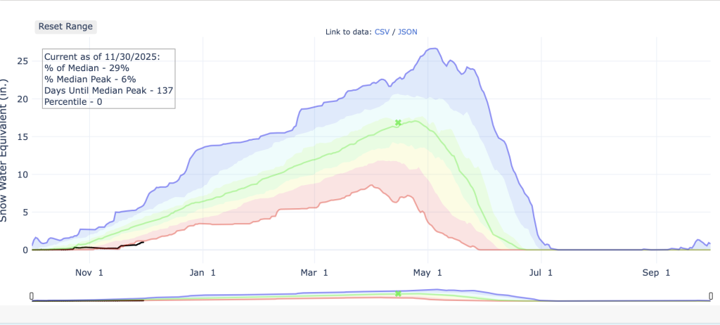
Summit reaches 29% of its 30-year median snowpack levels with more snow slated for this week

Kit Geary Follow

Arapahoe Basin Ski Area/Courtesy photo
Forecasts show some slight relief, but not too much, from the low-snow start to Colorado’s High Country ski season could be on its way.
National Weather Service forecaster Bruno Rodriguez said Summit County and parts of the Western Slope were seeing more active weather patterns picking up on Sunday, Nov. 30, that are expected to carry on into the beginning of the week. Meteorologist-founded app OpenSnow’s forecasts show chances of snow throughout the week for many High Country ski areas.
According to snowpack data from the federal National Water and Climate Center, Summit County is at 29% of the 30-year median for snowpack levels. It demonstrates the area is around 137 days away from reaching its 30-year median peak.
Rodriguez said weather models show Sunday’s storm going into early Monday morning was expected to favor places further west in Summit County, like Copper Mountain, and will be even better for places west of Summit, like Vail Pass. He said high-altitude areas in Summit could get around 3 to 6 inches — but areas like Vail Pass and the Gore Range will be some of the first to get hit by the system in the mountains in central west Colorado with forecasts showing some high-elevation areas getting 8 inches.
OpenSnow reports there could be around 3-6 inches for Copper Mountain, Winter Park Resort, Breckenridge Ski Resort, Keystone Resort and Arapahoe Basin Ski Area Sunday into Monday.
In his weather report, OpenSnow meteorologist Sam Collentine said he is keeping his eye on Beaver Creek Resort and Vail Resort as having the potential for the deepest totals by Sunday evening. OpenSnow reports Vail Resort and Beaver Creek Resort could accumulate upwards of 3-6 inches starting Sunday afternoon heading into Monday. Its forecast shows mountains like Telluride Ski Resort, Silverton Mountain, Wolf Creek Ski Area will likely come out of the weekend with the most snow.
Rodriguez said Monday is expected to dry out, but bring some colder temperatures. He said high-elevation areas in Summit could see temperatures in the mid-teens and wind gusts up to 40 miles per hour.
“I would advise folks to be pretty bundled up, especially if they’re doing any outdoor recreation,” he said.
Collentine wrote in his weather updates Monday and Tuesday should provide strong snowmaking conditions.
Rodriguez said there is a small chance of snow in the latter half of Tuesday. Temperatures could warm up a bit Tuesday day to a high of 23 in higher-elevation areas before dropping to a possible low of 5 degrees Tuesday night.
“Right now we’re focusing on Wednesday as the main event with our next system,” he said “(There’s) fairly high confidence in another system bringing a few more inches. … But there’s still a fair bit of uncertainty as far as the exact (snow) amounts with that.”
In his report, Collentine wrote he was hesitant to get too excited about the storm because it has the potential to go south.
According to OpenSnow, mountains like Copper Mountain, Breckenridge Ski Resort, Winter Park Resort, Vail Resort, Arapahoe Basin Ski Area, Keystone Resort and Beaver Creek resort could get around 3 to 4 inches Wednesday. It demonstrates Thursday and Friday could possibly bring an inch of snow each to these areas.
The app’s forecast shows, as of around noon on Sunday, that next Saturday could bring the next meaningful storm, particularly to areas west of Summit like Vail and Steamboat.
Rodriguez said Summit might not see overly favorable precipitation anytime soon.
“We’re not seeing any notable signals for anything too substantial in the couple weeks. … There’s still some opportunities for some snow on and off,” he said.
He said models currently show mostly low-pressure systems that will brush the northern part of the state.


Support Local Journalism
Support Local Journalism
As a Summit Daily News reader, you make our work possible.
Summit Daily is embarking on a multiyear project to digitize its archives going back to 1989 and make them available to the public in partnership with the Colorado Historic Newspapers Collection. The full project is expected to cost about $165,000. All donations made in 2023 will go directly toward this project.
Every contribution, no matter the size, will make a difference.