Meet Your Mountains: Hiking guide to Mount Guyot near Breckenridge, Colorado

Caroline Lewis Follow
-
Mount Guyot is a 13er right outside of Breckenridge. From state highway 9, Guyot can be seen on the left side of Bald Mountain.
Caroline Lewis / clewis@summitdaily.com |
-
From the moment Little French Gulch leaves treeline, hikers are greeted with a series of scree fields and alpine meadows to tackle before the summit of Mount Guyot.
Caroline Lewis / clewis@summitdaily.com |
-
An old cabin sits at the precipice below Guyot's summit. From the cabin to the summit of this 13er, there is about 800 feet of elevation gain left.
Caroline Lewis / clewis@summitdaily.com |
-
-
Looking towards Bald Mountain, another 13er accessible from Breckenridge, from the summit of Mount Guyot. Both mountains are visible from downtown Breckenridge.
Caroline Lewis / clewis@summitdaily.com |
-
Little French Gulch trail is mainly used by mountain bikers, but is a straight shoot to the scree yard underneath Mount Guyot. It can be accessed from Wellington Road in Breckenridge.
Caroline Lewis / clewis@summitdaily.com |
-
Looking down the first scree field towards where Little French Gulch leaves treeline, and all sense of trail is lost.
Caroline Lewis / clewis@summitdaily.com |
-
The author standing on Guyot's rocky spine. This left-most line is the path of least resistance, yet poses a serious amount of exposure for hikers. This isn't for the faint of heart.
Caroline Lewis / clewis@summitdaily.com |
-
The author standing some 300 feet below the summit of Mount Guyot, pointing towards Little French Gulch in the far distance.
Caroline Lewis / clewis@summitdaily.com |
-
Scattered below Mount Guyot there are rock cairns stacked designating the easiest path to its summit. The left-most line is the most efficient, yet very steep and exposed.
Caroline Lewis / clewis@summitdaily.com |
-
Looking up the steep boulder yard towards the summit of Mount Guyot. The boulders here defied logic, moving underfoot without any warning.
Caroline Lewis / clewis@summitdaily.com |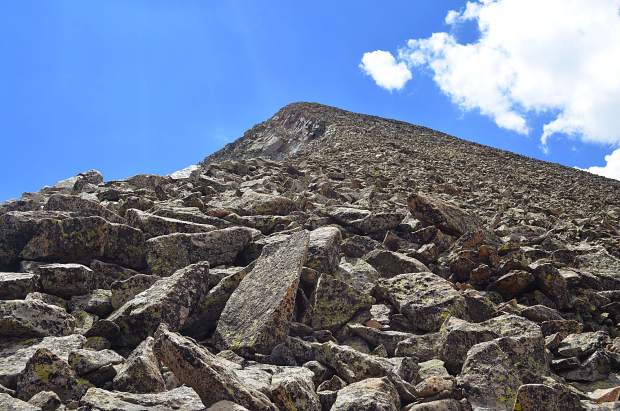
-

-
Looking down Guyot's rocky spine towards the ever-so-expansive valley of Park County. From Guyot's summit there are mountain ranges as far as the eye can see.
Caroline Lewis / clewis@summitdaily.com |
By the numbers
Mileage: 7.5 miles round trip
Time: 5-6 hours
Elevation gain: 9,950-13,376 feet (3,426 vertical feet)
Getting there: Drive to Breckenridge. Once in Breckenridge, turn east onto Wellington Road. Follow Wellington through the residential area until the road turns completely to dirt at French Gulch Road. Drive about 4 miles on the dirt road. Near the end is a trailhead on your right with space for parking. Park here. Continue on foot past the metal gate that blocks car traffic. After about 1.25 miles hiking the dirt road, look for the Little French Gulch trailhead on your left. Take this to the base of Mount Guyot.
Welcome to Meet Your Mountains, a hiking guide series covering four iconic peaks found just outside your back door in Summit County. Read on for locals route guides to: Peak One in Frisco, Buffalo Mountain near Silverthorne, and Bald Mountain (aka Mount Baldy) and mysterious Mount Guyot outside of Breckenridge.
Most hikes with a summit as the end goal are such teases. Chances are you can see the rocky summit the entire way, as if the mountain’s wiggling a taunting finger in your face. When you accept the challenge, you must show the mountain a similar toughness.
As we walked down the dirt road of French Gulch, my hiking partner Oliver and I could see Mount Guyot looming above the tree line.
“Alright, Guyot. I see you,” I kept saying.
To me, acknowledging the bada**ery of a mountain is crucial. I am looking up at its apex, visually measuring the elevation gain from trailhead to summit and verbally accepting the challenge. It’s like getting nose to nose with an opponent — standing on the tips of your toes, eyes locking. With clear skies a couple minutes past 9 a.m., we were a couple hundred yards into our trek. Shortly, we’d be knocking on Guyot’s door.
LITTLE FRENCH GULCH
The first mile en route to Guyot is easy to crush. It’s essentially a flat, dirt road that leads hikers through a backcountry settlement with a couple homes scattered on either side. In 20 minutes we’d reached Little French Gulch trail, and from the very start of this trail it was uphill. A shaded aspen grove was atop the first crest of Little French Gulch. By then, we’d only seen one person on this trail: a mountain biker who was riding to Georgia Pass.
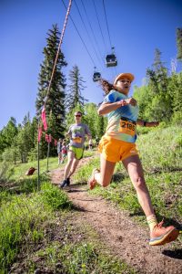
On the right side of Little French (home to one of the nastiest climbs at the Firecracker 50) were a series of small waterfalls that resonated sound in an otherwise very silent gulch. The steep dropoffs on the right side would have made me nervous had I been on my mountain bike. For hikers who also mountain bike, I would suggest riding the road to Little French, and then continuing up until you reach the scree field. Leave your bike by the boulder yard, bag the peak, then ride back down. This is an alternate approach method that I, in retrospect, wish I had tried.
Descending slightly, Little French dipped back down to the gulch floor after topping out. A stream runs right through the middle of Little French Gulch and there is an old cabin on the left side of the trail. It appeared to be no longer in use — a dormant mining cabin I assumed. Vibrant Indian paintbrush and fireweed brought color to the trail.
Above tree line
Little French Gulch sort of dissolves into a deluge of scree and the clear trail ceases when you reach the outer rim of Guyot’s boulder yard. Just before leaving the initial break in tree line, Little French Gulch forks. Going left at this fork allows hikers to explore the gulch and stream area more. Going right takes hikers higher, more specifically toward the summit of Guyot. At this fork there is large downed log laid across the trail with an animal skull on it. Bear right here.
Taking the right fork, the trail finally opens up outside of the forest. From here, we could really see what we had left to do. From the break in tree line, hike another 0.25 miles until you reach the mine structures and scree yard. This is where decision making is important. The approach can be tackled in numerous ways — it’s all up to the hiker.
From our vantage point by the scree yard, we saw a well-traveled line in the scree on the far left (north, when looking up toward the summit). The left-most line seemed to take us up the first section of scree and onto the ridgeline. It was no picnic: Our calves were burning from scrambling over very steep terrain with loose rock. We estimated that we covered about 600 feet of elevation gain here in less than 0.5 miles.
After 20 minutes of pushing upward on the scree, we topped out on our first ridgeline shelf. There were more options here: We could push up the next slope that we faced head on, or go left (north) again, traversing the second, wider slope. I spotted what appeared to be a trail, or, at the very least, a well-beaten path through the scree.
Shout Out to the goats
This faint path was likely a wildlife trail made by the local mountain goats. The wildlife know their way very well, and so we trusted this trail. This traverse was much easier than hiking straight up a scree-covered hillside. We easily moved across talus and after about a half-mile reached a gorgeous alpine meadow. We could see the summit clearly — or so we thought.
Moved by sheer excitement, we carried ourselves through the meadow quickly, practically running as we reached the ridgeline. At the top of this meadow ridgeline there was another old cabin. It rested practically on the ridge’s rim, as if in winter one could step outside it and ski right down the cliff edge.
Here, we still had another 800 vertical feet until we hit the summit and it wasn’t going to be easy. We took a break to refuel at the bottom of Guyot’s boulder field, then pushed on for another 45 minutes without stopping. This portion required real concentration. Boulders here defied all logic — boulders that should have been too large to budge would move from under you without the slightest warning.
At one point, I vocalized the fact that we were literally climbing atop an enormous loose pile of rock. That’s all this craggy summit was — sturdy and uniform from afar, but malleable and prone to movement up close.
left line is key
On the ascent, we started out following a trail that hugged the left-most ridgeline. It was extremely steep here, giving hikers direct glimpses into craggy couloirs. We were nervous being this close to the precipice, so we started moving to the right, following a more central line to the summit. The summit was absolutely stunning, equally as amazing as the summit of Quandary Peak or any other 14er I’d hiked.
The spine of Guyot unfurled to the right and left of the official summit, so we roamed its craggy ridgeline for some time. There was an absolutely amazing alpine lake directly below Guyot to the east, and an expansive view of the Front Range and Park County. We could see Pikes Peak far, far in the distance to the south, and the huge mountains surrounding Hoosier Pass to the southwest. Spinning around in a full circle, there were rolling hillsides, mountain ranges and Jeep roads everywhere I looked.
Unfriendly clouds began to team together near the summit, so we eventually had to pull ourselves away from Guyot’s incredible summit. On the way down, it became even more apparent to us that the left-most line (now on our right, as we descended) was crucial. It was the most “trail-like” of the beaten paths up Guyot. It was more sturdy than the other lines we’d tried on the upward approach.
If I ever summit Guyot again (which I would do in a heart beat), I’d take this left-most line. Use caution because of the steep drop-offs, but don’t be scared away from it.


Support Local Journalism
Support Local Journalism
As a Summit Daily News reader, you make our work possible.
Summit Daily is embarking on a multiyear project to digitize its archives going back to 1989 and make them available to the public in partnership with the Colorado Historic Newspapers Collection. The full project is expected to cost about $165,000. All donations made in 2023 will go directly toward this project.
Every contribution, no matter the size, will make a difference.