Severe storms with damaging winds and hail on Monday are forecast to give way to scattered showers on Tuesday that will fall as snow at higher elevations. The storms could bring 35 mph winds and slick travel on mountain passes, the outlook states.
Wednesday through Friday will be warm and dry, but isolated showers and thunderstorms are possible in afternoons and evenings, mainly across the High Country.
Rain and snow showers are likely before 4 p.m., and then snow showers are likely from 5 p.m. and into the evening. Lightning is also possible with this storm system, according to National Weather Service reports.
Colorado snow totals: May storm brings around half-foot of snow for several ski resorts’ closing days, boosts snowpack above normal as other areas remain open
Several Colorado ski areas enjoyed around a half-foot of snow for the final days of the 2023-24 season thanks to a mid-May storm this past weekend.
Loveland Ski Area and Breckenridge Ski Resort both netted 4 inches of fresh powder between Friday, May 10 and Sunday, May 12 — the final day of the ski season for both. Copper Mountain Resort, which also closed out its winter activities on May 12, saw 6 inches during that time, according to data on OpenSnow.com.
Arapahoe Basin Ski Area and Winter Park Resort, the only two ski areas still open in the state, saw 11 inches and 1 inch, respectively.
Snowpack levels for the Colorado River Headwaters Basin, which includes central and northern mountain areas as well as parts of the Western Slope, also surged over the past few days. As of Monday, May 13, snowpack levels stood at 117% of normal, according to data from the Natural Resources Conservation Service.
Here’s where snow totals stand at Colorado’s ski resorts for May 10-12, according to OpenSnow:
Steamboat Resort: 0 inches
Granby Ranch: 0 inches
Crested Butte: 13 inches
Winter Park Resort: 1 inch
Eldora: 6 inches
Copper Mountain Resort: 6 inches
Arapahoe Basin Ski Area: 11 inches
Wolf Creek: 14 inches
Loveland Ski Area: 4 inches
Vail Mountain: 4 inches
Breckenridge Ski Resort: 4 inches
Beaver Creek: 3 inches
Silverton: 11 inches
Ski Cooper: 8 inches
Keystone: 5 inches
Telluride: 5 inches
Snowmass: 11 inches
Aspen Mountain: 10 inches
Buttermilk: 2 inches
Purgatory: 7 inches
Sunlight: 3 inches
Thought your house might blow over during the storm? Here’s where the wind whipped the wildest in Colorado.
The strong winds blew for hours on end Monday across Colorado, culminating in impressive top speeds across the state. Here’s some of the strongest gusts, 60 mph or above, according to National Weather Service reports:
Gilpin County, near Dakota Hill, 87 mph
Clear Creek County, near Interstate 70, Empire Junction, 86 mph
Summit County, near Copper Mountain, 85 mph
Jefferson County, near Rocky Flats, 81 mph
Boulder County, near Boulder, 80 mph
Douglas County, near Greenland, 79 mph
Grand County, near Berthoud Pass, 77 mph
Arapahoe County, near Aurora, 76 mph
Larimer County, near Virginia Dale, 67 mph
Weld County, near Wyoming border, 61 mph
Park County, near Wilkerson Pass, 60 mph
Elbert County, near Monument Hill, 60 mph
Surprise spring storm brings weather advisories, heightened avalanche danger to the Colorado Rocky Mountains
It’s May on the Western Slope and instead of sunshine and flowers, many areas in the Rockies have been placed in a hazardous weather advisory as high-Alpine areas are under “moderate” avalanche risk.
The National Weather Service in Boulder placed areas that are above 9,000 feet in Summit, Clear Creek, Gilpin and Grand counties under a winter weather advisory due to hazardous conditions expected until 11:59 p.m. Tuesday.
The weather advisory states that people should expect wind gusts as high as 60 miles per hour, especially on mountain passes, and that driving conditions could be dangerous.
Forecaster Greg Heavener said that the Summit County and Eagle County could see 5-10 inches by late Wednesday morning. Heavener said a majority of the snow is anticipated to wrap up by Tuesday night. but Wednesday morning could bring another 3-4 inches.
Heavener said the wind pushed the storm to the hazard-advisory level. He said a low pressure weather system pushed into the Rocky Mountains from Wyoming to cause the storm.
“That put a strong amount of wind almost directly west to east across the Continental Divide, and all that wind energy with some moisture slammed into the west side of the slopes there and produced the snowfall,” Heavener said.
Heavener said things will start to slightly warm up by the time the weekend rolls around, and people can expect warmer weather to melt some of the snow.
The Colorado Avalanche Information Center posted on its Facebook page May 6 that the week’s weather warrants people to break out their “winter-like pattern recognition.”
In the post, the agency said “look for and avoid drifted areas especially below ridgelines, downwind of terrain features, or along gully walls.”
It said strong wind can be loading in unusual places, such as cross-loaded features and further down slopes. It added weather such as this can cause snow to pile up to be several feet deep in certain areas and the snow could be heavy enough to bury or injure someone.
The agency also said small slides in this weather could be dangerous, and people should be aware of subtle changes.
Heavener noted that snow storms during “mud season” could pose risks for avalanches or slides due to variable spring weather. Freezing, thawing, precipitation and wind can impact different layers of snow and could play a factor in avalanche lines.
According to a Colorado Avalanche Information Center report posted on the morning of Tuesday, May 7, above and near treeline areas in Routt, Summit, Eagle and Grand counties are considered to be at “moderate risk” for avalanches.
While it might be a risky time to venture into the backcountry, a handful of ski resorts in the area are still open.
Breckenridge Ski Resort remains open, and according to meteorologists-run blog OpenSnow.com, it is expected to get 7 inches of snow by Saturday. OpenSnow also reports that Arapahoe Basin Ski Area could get as many as 11 inches by Saturday, and Copper Mountain could get as many as 8 inches.
Here’s how the 2023-24 ski season compared to past years, according to meteorologists
Another ski season is nearing its end in the Colorado High Country. For meteorologists, “average” is the word that comes to mind when they think about this winter and spring compared to others.
“My parting thought about this season was that I was happy with ‘average,'” wrote OpenSnow.com founding meteorologist Joel Gratz in a May 1 blog post.
“Sure, we can always hope for more snow, but an ‘average’ season is still pretty good and offers plenty of opportunities for powder days, sunny skies, and everything in between,” Gratz continued.
For about half the season, from November through mid-January, snowpack levels throughout the state were significantly below the 30-year-median, according to data from the Natural Resources Conservation Service. Then, in mid-January, snowpack began to surge, straddling the 30-year median. For a month between March 14 and April 14, levels were above the normal threshold.
Specific basins saw greater snowpack than what was reported statewide, such as the Colorado River Headwaters Basin that encompasses a slew of high-profile ski areas including Breckenridge Ski Resort, Copper Mountain Resort, Vail Mountain and Beaver Creek.
The Colorado River basin’s snowpack levels held consistently above the 30-year median beginning on March 4 — 10 days before the trend was seen statewide — and through mid-April, though levels had briefly pushed above normal a few times earlier in the season.
In Summit County, for example, that meant above-average snow accumulation for some areas. In Dillon, a SNOTEL site recorded 134.5 inches of total snow accumulation between September and April, according to National Weather Service meteorologist Bernie Meier.
The seasonal average for that site is 108.4 inches. During the 2022-23 season, the site recorded 105 inches for the total season, which ends in June, while in 2021-22 it recorded 111 inches, Meier said.
Another SNOTEL site in Breckenridge recorded 144.7 between September and March and has not yet reported its April figures, Meier said. But it puts the site at just below normal for snow accumulation through March, with average accumulation for that time being 146 inches.
Looking at the Colorado River basin as a whole, “The seasonal precipitation came in at 101%, so almost as normal as you can get,” Meier added.
Snowpack for the Colorado River Headwaters Basin, which includes central and northern mountain areas, lagged behind the 30-year-median for much of the first-half of winter before surging in January. Levels followed the 30-year-median before rising above normal in March and the first half of April before plunging below normal. As of May 6, snowpack was at 89% of the median.Natural Resources Conservation Service/Courtesy illustration
Zooming in on a ski area like Copper Mountain, snow base depth remained strong for much of the season, according to OpenSnow meteorologist Sam Collentine.
In a a May 1 blog post, Collentine stated that a review of Copper data showed that the resort was 69% below the 30-year normal snow depth in November and 17% below in December but was 32% above in January, 9% above in February, 30% above in March and 34% above in April.
“According to our monthly snowfall chart for Copper Mountain, we recorded 14 powder days with 6 inches or more from December through April,” Collentine wrote.
Stay up-to-date on all things Summit County. Get the top stories in your inbox every morning. Sign up here: SummitDaily.com/newsletter
Other resorts that extended seasons included Steamboat Resort, which extended its ski activities by a week from its original end date, closing on April 21. Last season, the resort closed on April 16. Prior to then, Steamboat had not extended its season by a week or more since 1993.
Others, like Breckenridge and Arapahoe Basin Ski Area, have yet to announce a closing date. Last season, Breckenridge closed on May 21 while Arapahoe Basin closed on June 4.
In his 2023-24 season preview published in August, Collentine predicted that with the switch to an El Nino pattern, Colorado would see average snowfall with the potential for a stronger start and end to the season.
“This winter forecast preview tended to be right on the mark with a snowpack hovering right around the 30-year normal by the time we reached the peak snowpack in late April,” Collentine wrote in a May 1 blog post on OpenSnow.com.
El Nino refers to the warming of surface temperatures of the Pacific Ocean off the coast of South America and the subsequent change in the jet stream that can occur. Typically, this translates to less snow and dryer conditions in the northern U.S. with more snow and wetter conditions in the southern U.S.
An OpenSnow graphic shows the usual impacts of El Nino on the U.S. Colorado usually sees less impact from the pattern compared to other regions, making El Nino’s effect on mountain conditions hard to tell. OpenSnow/Courtesy illustration
The pattern, however, has little correlation on conditions in the country’s central regions, including much of Colorado, making it hard to discern El Nino’s effects on the High Country.
La Nina is likely to persist into the fall and winter as well, with an “80-90% chance for a La Nina during the winter of 2024-2025,” Gratz stated in his May 1 post.
Gratz added while he has “low to no confidence” in predicting snowfall so far out, La Nina tends to be the opposite of this season’s El Nino, meaning next season, “could bring average to above-average snow to Canada and the northern Rockies and possibly below-average snow to the southwestern U.S.”
But once again, Colorado falls in-between both zones, “so anything could happen,” Gratz stated.
80mph winds, snowfall place Summit County under winter weather advisory as gusty weather disrupts some ski lifts
Between 3-8 inches of snowfall and wind gusts as high as 80mph above timberline have Summit County under a winter weather advisory, according to the National Weather Service of Boulder.
The advisory expires at 6 p.m. Monday.
Breckenridge Ski Resort released information on social media saying the gusty weather caused disruptions to some of its lifts on Monday.
According to National Weather Service forecasts, winds will continue to be strong with gusts near 50 mph Tuesday and 1 to 2 inches of snow possible. Wednesday will be breezy but mostly sunny with a high near 42 degrees and gusts up to 25 mph.
Intermittent snow showers are possible through Sunday.
Hazardous weather outlook says few inches of snow possible for Summit County, Colorado mountains this weekend
Up to 4 inches of snow could accumulate by Saturday afternoon across northwest Colorado, according to a hazardous weather outlook issued by the National Weather Service.
The snowfall outlook is forecast for elevations above 8,000 feet, and the Park Range is most likely to see the highest snow totals. A few showers thunderstorms are possible through Saturday before things are expected to clear out and warm up, but chances for light snow return Sunday, lasting through Monday.
According to long-term forecasts issued by the National Weather Service, light snow showers are expected to stick around all next week through Friday.
Snowshoer walks off cornice during white-out storm, triggers 2 avalanches on mountain near Breckenridge
A snowshoer fell off a cornice and slid roughly 900 feet after becoming disoriented during a white-out storm on Sunday, April 28, on Bald Mountain, according to a Colorado Avalanche Information Center field report.
He reportedly triggered a D1 storm slab avalanche, the smallest on a five-point scale, while attempting to climb back out, so he called 911, which initiated a search and rescue response. While trying to traverse to another ridge, a second avalanche was triggered but he wasn’t carried with the debris like he was with the first avalanche, according to the report.
Summit County Rescue Group member Charles Pitman, who was part of the rescue efforts, said the man was from outside of the county but was familiar with the area. Pitman said the snowshoer started his day around 8:30 a.m., but he decided to abandon a summit attempt after the weather turned for the worse, according to the avalanche center report.
“All of the sudden, the weather just turned into a white out,” Pitman said. “It was massive snow, lots of wind, and the snow conditions were a little sketchy. He couldn’t tell one direction from another. One more step in the wrong direction had him on top of the cornice.”
The man luckily had cell reception and was able to talk to rescuers as they made their way up toward him. The rescue group used a snowmobile to get a rescue crew up close to the snowshoer. Knowing the cornice and snow may be reactive, Pitman said it took a while to assess the situation and find an area to access the man.
Rescue crews set up snow anchors and 200-foot ropes so that they could reach him and put a harness on him. Pitman said he was eventually extracted without issue or injury with all crews out of the field by 4:20 p.m.
Pitman said while the man was well prepared with warm clothing, food and water, it’s always helpful to have a GPS device so you can orient yourself and beware of where ridgelines, and likely cornices, may be. He said some can be 50-feet long and break, causing considerable avalanches capable of burying or killing a person.
He also advised that spring weather can often “lull people into a false sense of security” but that snow conditions this time of year can change rapidly. The snowpack often gets less stable and more reactive as it begins to heat up, increasing the risk of wet avalanches. Storms can also come in with little to no notice.
The Colorado Avalanche Information Center is warning of avalanche danger caused by the recent storm that caught the snowshoer off guard.
“Statewide, you can trigger avalanches in wind-drifted snow at higher elevations. In the last week, 14 people were caught in avalanches —most of them due to wind-drifted snow,” the center wrote in a social media post that highlighted an incident that occurred in Montezuma in Summit County on April 30. “Avoid stiff smooth drifts on steep slopes below corniced ridgelines and in cross-loaded alpine gullies. Choose wind-sheltered or wind-scoured terrain to avoid the problem. Be especially mindful in consistently steep or cliffy terrain.”
Winter storm to bring feet of snow at high elevations in Colorado mountains, ski resorts, meteorologists say
With up to 6 inches of fresh snow at most open ski resorts in Colorado as of Friday morning, another storm is expected to bury parts of the state by Sunday, April 28.
While most towns and ski areas won’t see nearly as much snow accumulate, elevations above 10,000 feet could see between 1-3 feet pile up by Sunday afternoon, according to a winter storm watch issued by the National Weather Service Friday evening.
The watch is in effect for Rocky Mountain National Park, the Medicine Bow Range, the mountains of Summit County, the Mosquito Range and the Indian Peaks. Most mountainous areas of the state are also under weather alerts, with snow totals up to 18 inches.
OpenSnow founding meteorologist Joel Gratz said there will be a lull in the storm Friday night before things intensify Saturday. Intense snow is expected to begin Saturday morning at dawn and last through the afternoon, with 12-20 inches possible.
The mountains of Colorado are expected to get up to 18 inches of snowfall, with some areas above 10,000 feet elevation receiving up to 3 feet by Sunday afternoon, April 28, 2024. OpenSnow/Courtesy illustration
Gratz said his confidence is high since winds will be coming from the east all the way up to 30,000 feet, which is “the main ingredient for intense snow” in the area near and east of the Continental Divide.
“For snow conditions, there should be free refills on Saturday for mountains near the divide, like (Arapahoe Basin Ski Area), (Loveland Ski Area), and (Winter Park Resort), and mountains farther west of the divide, like (Breckenridge Ski Resort), (Copper Mountain Resort), and (Vail Mountain) should also see significant snow but with intensities that could be lower than near then dividem,” Gratz said.
The intensity of the snowfall is expected to make travel treacherous, especially over mountain passes.
Snowfall could continue into Sunday morning as the storm moves east of the Rocky Mountains.
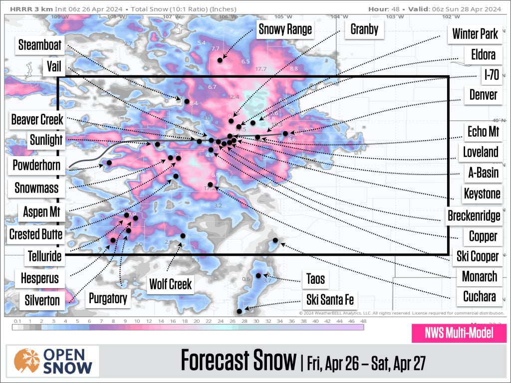
Possible spring powder day in the forecast for multiple Colorado ski resorts, mountains, meteorologist says
With the sun starting to set later in the day and the weather starting to slowly warm up in the High Country, snow storms are becoming less frequent.
Although the weather this week has been dry with mild temperatures, forecasters at OpenSnow.com are currently tracking a system that is predicted to bring significant snow to much of Colorado’s mountains this weekend.
According to OpenSnow founding meteorologist Joel Gratz, the Colorado High Country will see multiple rounds of snow from Thursday afternoon through Sunday afternoon, with the majority of snow showers predicted to all develop in the overnight hours where snow accumulation is possible.
“Now that we’re in late April, the best chance for snow to accumulate is when the sun is not shining, which is nighttime,” Gratz said in his blogpost. “With nighttime as a goal, the upcoming storms will be timed pretty well, with rounds of snow falling on Thursday night, Friday night, and again on Saturday night through Sunday midday.”
Snow plumes up around a skier as he plows through more than a foot of fresh powder at Arapahoe Basin Ski Area on Tuesday, April 16, 2024.Lucas Herbert/Arapahoe Basin Ski Area
OpenSnow expects to see 1 to 5-plus inches on Thursday night, 3 to 6-plus inches on Friday and 6 to 12-plus inches from Saturday evening through Sunday midday. Temperatures are expected to stay fairly high during the storms, so snow could fall to 8,000-9,000 feet at times with the best chance for deeper accumulations and decent snow quality at elevations above 10,000 feet.
With Winter Park Resort, Breckenridge Ski Resort, Arapahoe Basin Ski Area, Loveland Ski Area, Purgatory Resort and Copper Mountain Resort all still open for winter operations, there should be decent snow quality on the upper part of the mountains, with the best chance for the deepest powder on Sunday morning through midday.
Although these are the only resorts that are still open in Colorado, the storm is expected to span the entire state and deliver snow totals within these ranges for mountains around 9,000 feet in elevation.
OpenSnow predicts next week to be dry and warm with the next storm arriving between Friday, May 3, and Monday, May 6.