Exploring the visible geology of Summit County
Special to the Daily
ALL |
In the distant past, pressures in the Earth’s crust squeezed and pressed granitic rocks into flattened plates called metamorphics. This type of rock can be seen between Silverplume and Floyd Hill. We will come back to these rocks later.
The Earth’s surface rises and falls due to the pressures within. Seas once invaded Colorado and laid down some 1,000 feet of limestones and sandstones. These rocks can be seen in Glenwood Canyon.
Then we had a mountain building period called the Ancestral Rockies. There were two ranges, one where the present Front Range is, the other in the western part of the state. As these mountains arose, erosion began stripping away these limestones and sandstones and eventually nearly leveled these granitic mountains.
Erosional detritus formed an iron oxide stained sandstone. This red sandstone can be seen in Arizona and Utah and many places in Colorado such as Red Rocks Amphitheater, the Garden of the Gods, the Flatirons near Boulder and our own Red Mountain. Dinosaur bones have been found in this formation.
Again, the seas invaded, laying down a limestone that is seen tilted vertically on Boreas Pass, “the gap,” tilted on the road cut between Frisco and Farmer’s Korner, lying flat just east of Silverthorne and forming the cliffs on the north side of the east end of Lake Dillon. Although stripped from the mountains, it underlies much of the valley floors but is covered by soil. This sea then became muddy and deposited a massive amount of dark gray shale, visible near Green Mountain Reservoir. Most of this soft shale was eroded off the southern part of the county.
Once again the mountains were pushed up, our present Rockies.
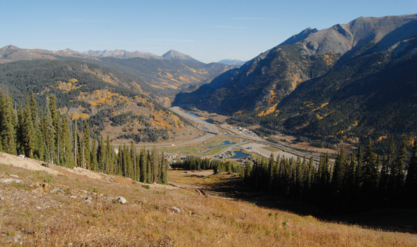
Along with this uplift there was much faulting (the movement of one block of rocks against another). A fault weakened rocks in the Tenmile and Gore ranges enough to allow the gravel bearing stream to cut the Tenmile Canyon. A fault weakened the granite on Loveland Pass. North-south faults allowed younger sedimentary rocks to slip lower than older granitics. Frisco and Silverthorne lie on a graben. A much older fault is evident as the denser metamorphics forming Peaks One through Three and are some 30 percent older than the granites to the south. Notice how differently these peaks were eroded. The metamorphics and granites form the Gore Range.
During the volcanic period that affected the western states, and as the San Juan mountains were being build, up flowed hot mineral bearing fluids, setting the stage for our gold rush.
During the glacial periods, ice covered much of Summit County above 8,000 feet. For example, glaciers cut the bowls on Peaks 7 and 8 as well as Arapahoe Basin. A glacier formed the cirque lake between Peaks 7 and 8. Rocks caught in ice cut striations on the walls of Tenmile Canyon. Glaciers formed our U-shaped valleys (a stream cuts a V-shaped valley). A glacial path can be seen on the east face of Buffalo Mountain.
As the ice began melting and dust blew in from the west along with detritus from the gray shale, it formed soil for vegetation and covered much of the once-visible geology.
All this described here took place in the last one third of the earths age.
Breckenridge resident Carl E. Fisher is a former geologist for the petroleum industry and holds a degree in geology from Oklahoma State University.


Support Local Journalism
Support Local Journalism
As a Summit Daily News reader, you make our work possible.
Summit Daily is embarking on a multiyear project to digitize its archives going back to 1989 and make them available to the public in partnership with the Colorado Historic Newspapers Collection. The full project is expected to cost about $165,000. All donations made in 2023 will go directly toward this project.
Every contribution, no matter the size, will make a difference.