Hike of the Week: Wilder Gulch

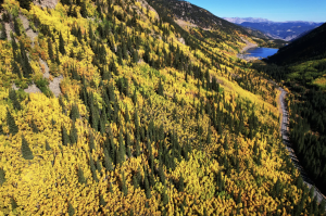
Lose your heart to a palette of fuschia, cerise, salmon and rose Indian paintbrush on Wilder Gulch’s slopes. July 15 to Aug. 1 is peak wildflower time on Vail Pass. Both Shrine Pass above and Wilder Gulch just below offer sun-splashed meadows with many sub-alpine zone flowers. Look for larkspur, snowball saxifrage (kitten’s paw), queen’s crown, mariposa lily and more. Take a picnic to this valley and enjoy the blossoms. The best flowers will be up high.
To get there, drive Interstate 70 west past Copper Mountain to the Vail Pass summit. (Look for Wilder Gulch, a valley on the left just below the pass summit.) Turn off at Shrine Pass exit 190. Cross over the interstate and park in the roomy rest stop parking area. Ute Indians used the Vail Pass summit as a hunting campsite for 7,000 years, according to carbon-dated evidence found here during I-70 construction.The trail begins at the south end of the parking lot and cuts across a brushy slope and grassy rise to drop at 0.5 miles into Wilder Gulch. Reach the footpath, go right and hike uphill on the north-northwest creek bank (right side) along a meadow. The route is an old road but the gulch remains closed to motorized vehicles in summer. When the trail forks, use the upper branch. It affords better views of the spectacular Tenmile Range and avoids a serious bog on the lower trail. The track stays in the meadow for two-thirds of the hike, then enters conifer forest. Curving through the trees, the path heads up an old telephone line cut, first moderately, then in a steep climb.
In a meadow up high, the trail divides. A right fork follows Wearyman Creek and Turkey Creek to Red Cliff, while a left fork goes over Ptarmigan Pass and drops into Camp Hale. Your path goes left.Soon you emerge from the trees to view Ptarmigan Hill, a rounded 12,143-foot bump, and Ptarmigan Pass, 11,765 feet. This hike ends on the saddle north of Ptarmigan Hill.A dirt road winds up to the pass summit. There are two Ptarmigan Passes in Summit County, one here and one near Dillon. This Ptarmigan offers great views of the Saguache Range and the jagged Gore Range-Eagles Nest Wilderness north-northwest. Add-ons to this hike are the short scramble up Ptarmigan Hill (right) or the more advanced climb to the 12,200 foot ridge and higher promontory beyond left.
As always, enjoy your hike!Mary Ellen Gilliland wrote The New Summit Hiker, a guide for 50 historic hiking trails near Breckenridge, Frisco, Copper Mountain, Keystone, Dillon and in the Ptarmigan Peak and Eagle’s Nest Wilderness Areas. The guidebook is available for $16.95 in Summit County and Vail bookstores, supermarkets and sporting goods shops or by calling Alpenrose Press at 970-468-6273. For additional trails information for both the Vail and Summit County areas, visit http://www.alpenrosepress.com.

Support Local Journalism

Support Local Journalism
As a Summit Daily News reader, you make our work possible.
Summit Daily is embarking on a multiyear project to digitize its archives going back to 1989 and make them available to the public in partnership with the Colorado Historic Newspapers Collection. The full project is expected to cost about $165,000. All donations made in 2023 will go directly toward this project.
Every contribution, no matter the size, will make a difference.


