Sunday update: Crosho Fire now 5 percent contained; evacuation orders cancelled for Zones 3 and 4
Steamboat Pilot
John F. Russell/Steamboat Pilot & Today
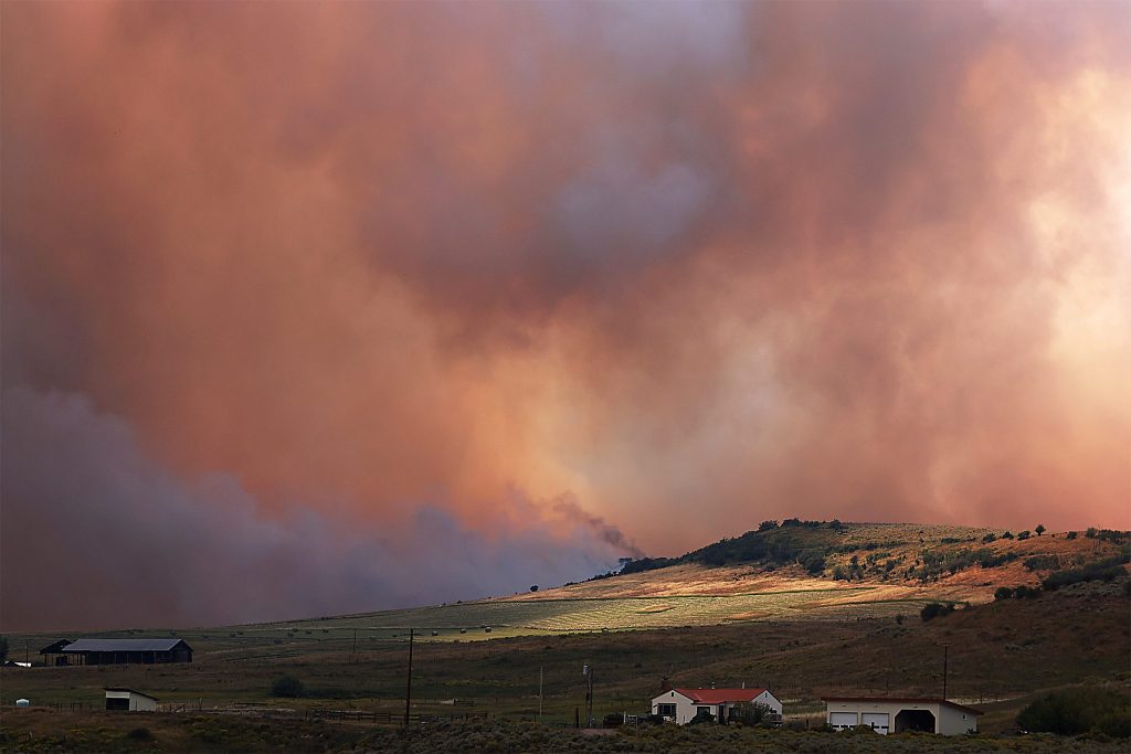
The Crosho Fire, west of Phippsburg and Yampa, has burned 2004 acres and is 5% contained as of Sunday morning, according to an update from the Wyoming Type 3 Incident Management Team.
The new acreage number, down from the 2200 acres previously reported, is “due to more accurate mapping,” the team wrote.
The blaze continues to threaten 240 structures in the area. No structures have been damaged or destroyed.
“Cooler temperatures and light precipitation continue to moderate fire behavior, allowing crews to engage on the perimeter,” the Sunday update wrote.
The height of the fire’s activity is located to the north of the coverage area near South Spronks Creek. “Firefighters are working to connect dozer and handline around the fire,” according to the update, though challenging terrain and overhead hazards are hampering progress.
“On the south side, crews are securing and mopping up areas of remaining heat while engines patrol,” the team added. Aerial resources are on call to support Crosho Fire personnel and “provide regional initial attack as needed.”
The cause of the fire remains unknown and under investigation as of Friday, according to U.S. Forest Service Public Affairs Specialist Aaron Voos. More details will be provided as they become available.
A total of 321 personnel, four dozers and four water tenders, as well as four aircraft and twelve engines, are working to suppress the fire as of Sunday.
A temporary flight restriction remains in place over the fire area.
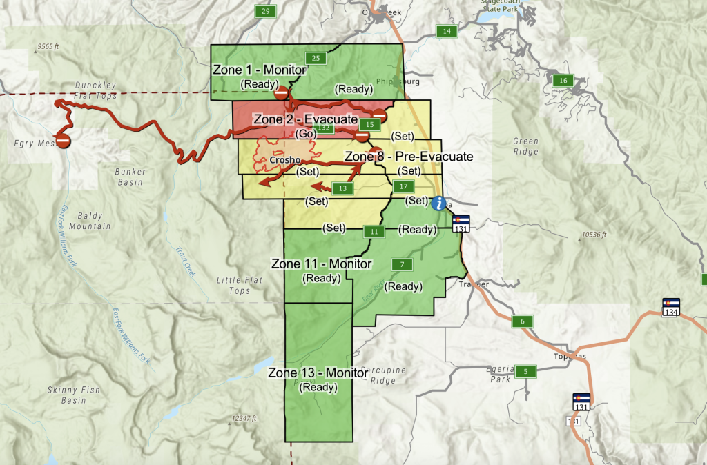
Zone 2 remains under evacuation, according to the Routt County Emergency Incident Map.
Zones 3 and 4, which were put under “Go” status on Wednesday, have been downgraded to “Set” as of Saturday evening, or from evacuation to pre-evacuation notice. Residents in Zones 3 and 4 are safe to return to their homes.
Zones 1, 6, 10, 11, 12 and 13 are under “Ready” status, while Zones 5, 7, 8 and 9 remain under “Set” status.
A map of evacuation zones can be viewed at TinyUrl.com/3p5b6rjw.
The following road closures have been implemented due to fire response efforts:
- Intersection of Routt County Road 15 and Routt County Road 17
- Intersection of Routt County Road 25 and Routt County Road 132A
- Rio Blanco County Road 8 (Dunckley Pass) at intersection of Rio Blanco County Roads 8 and 19
For updated fire information, visit the Crosho Fire InciWeb website at inciweb.wildfire.gov/incident-information/cortf-crosho-fire.
This story is from SteamboatPilot.com


Support Local Journalism
Support Local Journalism
As a Summit Daily News reader, you make our work possible.
Summit Daily is embarking on a multiyear project to digitize its archives going back to 1989 and make them available to the public in partnership with the Colorado Historic Newspapers Collection. The full project is expected to cost about $165,000. All donations made in 2023 will go directly toward this project.
Every contribution, no matter the size, will make a difference.